Detecting of
weakened zones in the geological basement of the Kola peninsula (north-eastern
part of the Baltic Shield, Murmansk region)
Filatova V.T.
Dr.
Sc.(Phys. & Math.), Lead Researcher,
Geological
Institute of the Kola Science Centre of the Russian Academy
of Sciences, Russia, Apatity
Abstract.
The Early Precambrian crust of the
north-eastern part Baltic Shield formed during a long geological period, and the observed structure reflects
the cumulative effect of multiple transformations. As a result, the
geological basement of the region acquired lateral and mosaic
heterogeneity.
This work has been carried out using methods of numerical modeling to detect weakened zones in the basement of
the region in regard to the construction and economic human activities. For this purpose, we have
constructed quantitative models of the stressed-deformed state of the Earth’s
crust in the region considering its evolution. Determined for the first time
are the structures that accumulated a tectonic-magmatic activity and produced mobile-permeable zones in the
Precambrian mainly. For the first time, we have found an interrelation between localities
of deep fractures (activation areas) and the stressed-deformed state of the
Earth’s crust caused by the impact of regional tangential stresses. The provided research indicates the necessity of studying the general
geological structure of the region and identifying setting areas of ancient
deep deformation structures in design and construction of the major industrial,
road, hydraulic engineering and other objects.
Keywords: Kola Peninsula, Earth's crust, Early
Precambrian, stress fields, numerical modeling, mobile-permeable
zones, magma feeding
channels,
geological assistance of construction, geophysical assistance of construction.
Introduction. The Murmansk
region contains great sources of the most important
types of mineral raw materials that predetermined the
creation of a powerful mining complex. Currently, more
than 100 mineral deposits in the region have a high investment and industrial
value. At each
step of designing and constructing industrial, power engineering (especially
nuclear power plants), hydraulic engineering, road and other facilities, it
becomes necessary to study the general geological structure of the basement in
the region and obtain physical-geological estimates of its strength properties. Solving
these tasks in mining areas, which location mostly correlates
with the areas of long-lived deep faults, is particularly topical.
Different
alternative geotectonic and geodynamic models for the development of the
northeastern part of the Baltic Shield are suggested and elaborated [1,2,5,9,10],
but up to the present time the processes that led to the specific structure and
composition of the ancient crust remain unclear. Interpreting the conditions that cause tectonic deformations is a most
essential part of reconstructing the geodynamic regimes predetermining features
of the regional development and affecting its metallogenic
specialization. One of the most essential features of the tectonosphere
is the stress and strain state that controls tectonic and geodynamic processes
in the crust. This work was
carried out using methods of numerical modeling to explain the dynamic features
of the formation of the magmatic structure system in the northeastern part of the Baltic Shield in the
period of 3.0 – 1.6 Ga. With this in
mind, we constructed quantitative models of the stressed deformed state of the
Earth’s crust in the region taking into account its evolutionary development.
For the first time, we determined the structures that facilitate the ascent of
mantle basic–ultrabasic magmas.
We
assume that the study region represented a nonuniform
elastic body subjected to the action of volume forces and specific stresses at
its boundaries. The problem of stresses was solved. The search for weak zones
in the basement, which predetermined the localization of magmatic processes,
was performed by estimating the maximum shear stresses. For the first time, we
found an interrelation of the localization of deep fractures (activation
regions) and the stressed deformed state of the Earth’s crust caused by the
action of regional tangential stresses. Our results allow us to understand the
causes of inheritance of the geodynamic activity regions in the Early
Precambrian and give grounds to revise the existing concepts about the
mechanism of the formation of the Earth’s crust in the northeastern part of the
Baltic Shield.
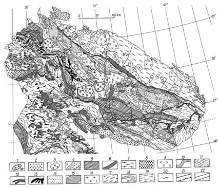
Figure 1 - Geological
structural map of the Kola region of the Baltic Shield (from [12]).
Domains: Mur - Murmansk, Kol - Kola, Bel - Belomorian, Ter – Tersky, Ke
– Keivy, In – Inary. Belts:
Jon – Yona, K-V – Kolmozero-Voronja
(Archean greenstone belts); LGB – Lapland, KGB – Kandalaksha-Kolvitsa (granulate belts); Pe
– Pechenga, Im-V – Imandra-Varzuga, S-K - North-Karelian (Early Proterozoic rocks); (1) contours of Paleozoic intrusions (a-nepheline syenite, b-ultramafic alkaline rocks); (2) Upper Proterozoic
sedimentary rocks. Early Proterozoic: (3)
granite, granodiorite and diorite; (4) charnokite and granite (a), alkalinegranite
(b); (5) volcanic-sedimentary rocks; (6) anorthosite
and gabbro-anorthosite (in Keivy
– Archean), gabbro, pyroxenite,
peridotite. Early Proterozoic (or Archean?):
(7) basic and intermediate granulite; (8) acid granulite. Late Archean: (9) granodiorite,
diorite and enderbite; (10) alumina and super-alumina gneiss and schist;
(11) acid gneiss; (12) fragments of
greenstone belts (gneiss, amphibolites and komatiite);
(13) fragments of banded iron formation
(gneiss, amphibolites and ferruginous quartzite); (14) gneiss and schist; (15) gneiss and amphibolites; (16) granodiorite and
diorite; (17) plagiogranite
and granite-gneiss; (18) kyanite-garnet-biotite gneiss;
(19) granite-gneiss, gneiss, migmatites and, rarely, amphibolites. (20) strike and dip; (21) subvertical faults
and gentry dipping thrusts that separate the Proterozoic domains; (22) subvertical faults
and thrusts. Encircled numbers
indicate type-sections: 1 - Keivy, 2 - Kolmozero, 3 - Ura-Guba, 4 - Kaskama, 5
- Korva, 6 - Ar-Varench, 7 - Voche-Lambina, 8 - Iona, 9 - Kovdozero, 10 -
Tersky.
Geological features of
the region. The northeastern part of the Baltic Shield is
characterized by a long and complex history of development, and the observed
structure reflects the cumulative effect of multiple transformations [12,14,15,16,18]. A significant part of the
study region is composed of Precambrian rocks [12,16]. These rocks, whose age
is 3.2–2.65 Ga [3,8], form the Murmansk, Kola, Belomorian, and Karelian Archaean
megablocks, which all together make up a collage
structure of the Earth’s crust in the region (Fig.1). The Archaean
Keivy structure embedded in the structure of the Kola
megablock is distinguished among the secondary
structures owing to the peculiarities of its structure [12]. In addition, the
following structural zones are significant: the Archaean
greenstone belts, i.e., Kolmozero - Voronje, Yona, and Tersky- Allarechka, and the Early
Proterozoic mobile belts, i.e., the Lapland granulate belt and Pechenga – Varguza rift belt, as
well as the giant Paleozoic alkaline intrusions (Khibiny,
Lovozero). The Early Proterozoic Pechenga
– Varguza rift belt inherits the development region
of the Archean Tersky - Allarechka belt. The Upper Archaean
– Early Proterozoic period is characterized by linear tectonics and formation
of belt structures, which were zones of repeated manifestation of mafic magmatism. All belt structures are divided by vast fields
of infra - supracrustal, deep metamorphic sialic complexes. Magmatic formations including those of mafic
– ultramafic composition play an important role in the development and
formation of the crust in the region. The major part of the presently known
mafic – ultramafic intrusions reveals spatial correlation with the zones of
deep persistent fractures and rift genesis.
Statement of the problem and
principal equations. In the Late Archaean, consolidation of the
Earth’s crust transformed the region into a relatively stable continental
structure, and by that time, the study region was in a stable state [4]. Hence,
we can admit that the region could have been subjected to overall uniform
compression owing to remote forcing. In the Early Proterozoic, the main front
of tangential stresses was directed to the northeast [16,18]. The Murmansk megablock was in a stable position. It is not improbable
that it was subjected to stress directed from northeast to southwest. Hence, we
admit that, in the Early Proterozoic, the region was subjected to monoaxial compression by uniformly distributed forces from
the southwest and northeast.
We assume that the northeastern part of the Baltic Shield over the entire
period of the geological history of the region represented an inhomogeneous elastic
body subjected to the impact of volume forces and specific stresses at its
boundaries. We also admit that (a) the tectonic magmatic activity established
in the Early Precambrian was of the intraplate type;
(b) the configuration of contact boundaries between the Archaean
megablocks did not change strongly over the entire
geological history. The region considered here consists of a few finite subregions. Each of them is considered uniformly isotropic
and linearly elastic with linear elastic constants (Poisson coefficient μ and Young modulus E). Each
Archaean megablock is a
separate subregion. The zones of deep fractures
dividing the Archaean megablocks
are considered as subregions with a width of 15–30
km. We specify the condition that the region is in the equilibrium state and
the components of the stress tensor ![]() in the case of the plane problem satisfy the equilibrium
conditions [13]:
in the case of the plane problem satisfy the equilibrium
conditions [13]:
![]() ,
, ![]() ,
,
 where
where ![]() and
and ![]() are volume forces. We used the
method of boundary elements to numerically solve this boundary problem with
respect to stresses. The numerical solution is constructed using previously
obtained analytical solutions for simple singular problems so as to satisfy the
specified boundary conditions at each element of the contour [6]. We consider
the upper horizontal surface of the solid medium model.
are volume forces. We used the
method of boundary elements to numerically solve this boundary problem with
respect to stresses. The numerical solution is constructed using previously
obtained analytical solutions for simple singular problems so as to satisfy the
specified boundary conditions at each element of the contour [6]. We consider
the upper horizontal surface of the solid medium model.
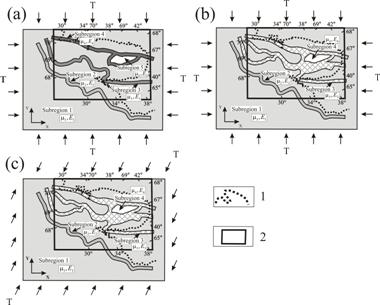
Figure 2 - Model
block regions: approximation schemes of the Earth’s crust block structure in
the northeastern part of the Baltic Shield for the period of 3.0–1.6 Ga.
(a) 3.0–2.8 Ga; (b) 2.8–2.5 Ga; (c) 2.5–1.6 Ga; (1)
contours of the modern coastline; (2)
contours of the study region; T is
force.
Three time stages of the Kola
region development were considered in the course of solving the formulated
problem (3.0–2.8, 2.8–2.5, 2.5–1.6 Ga), and
correspondingly, a certain basic model was specified at each of the stages that
describes the study region with account for the geological structures formed by
the corresponding time (Fig. 2). With this in mind, we defined a rectangular
contour for simulations that envelope the study region including the Murmansk, Kola,
and Belomorian megablocks
and the marginal region of the Karelian megablock in
the contact zone with the Belomorian megablock. The area of the specified contour significantly
exceeds the study region in order to exclude the influence of the contour boundaries
in the simulations. Stress T was
specified along the entire boundary in the numerical experiment. Since we do
not have reliable data on the absolute value of forces in the region, we assume
that their intensity T is equal
to unity and obtain stresses in the simulations in the units of T. Stresses ![]() ,
, ![]() ,
, ![]() were estimated for each basic
model, which allowed us to calculate the main stresses
were estimated for each basic
model, which allowed us to calculate the main stresses ![]()
![]() ,
, ![]() and the maximum absolute
values of shear stresses [13]:
and the maximum absolute
values of shear stresses [13]:  . The main
stresses were calculated using the following relations [13]:
. The main
stresses were calculated using the following relations [13]:

where ![]() is the angle between the axis
of the main stress with the OX-axis,
is the angle between the axis
of the main stress with the OX-axis,
![]() .
.
Finally, the values of stresses ![]() were
normalized and presented as percentage of the maximum value over the region.
Thus, after normalizing, the domains with anomalous shear stresses were
considered as weak zones in the basement of the region. All the works were
carried out using a scale of 1 : 1 000 000 and the initial geological chart of
the region with a scale of 1:500000 [11].
Simulations for several versions
of the load applied to the region were performed. In the case of overall
uniform compression of the region (Fig. 2a, 2b) and mono-axial compression
along the southwest–northeast line (Fig. 2c), the structural peculiarities of
the region caused by the development of the permeable zones of the Earth’s
crust were pronounced most clearly.
were
normalized and presented as percentage of the maximum value over the region.
Thus, after normalizing, the domains with anomalous shear stresses were
considered as weak zones in the basement of the region. All the works were
carried out using a scale of 1 : 1 000 000 and the initial geological chart of
the region with a scale of 1:500000 [11].
Simulations for several versions
of the load applied to the region were performed. In the case of overall
uniform compression of the region (Fig. 2a, 2b) and mono-axial compression
along the southwest–northeast line (Fig. 2c), the structural peculiarities of
the region caused by the development of the permeable zones of the Earth’s
crust were pronounced most clearly.
The values of linear elastic
constants (![]() ) for
the rocks of the Archaean megablocks,
greenstone belts, Keivy structure, and fracture zones
were specified according to the data presented in [7]. The Poisson coefficient
in the simulations for the Archaean megablocks (Karelian, Murmansk, Kola, and Belomorian) and the Keivy
structure was assumed equal to
) for
the rocks of the Archaean megablocks,
greenstone belts, Keivy structure, and fracture zones
were specified according to the data presented in [7]. The Poisson coefficient
in the simulations for the Archaean megablocks (Karelian, Murmansk, Kola, and Belomorian) and the Keivy
structure was assumed equal to ![]() = 0.25, while in the
weak zones it was
= 0.25, while in the
weak zones it was ![]() = 0.3. The zones of
deep fractures dividing the Archaean megablocks were considered weak. The Young modulus in each
of the subregions was determined as the weighted mean
value: in the Karelian, Murmansk, Kola, and Belomorian
megablocks, it was taken equal to E = 6.2 ⋅ 104 MPa,
and in the Keivy structure it was E = 5.8 ⋅ 104 MPa. In the weak (fracture)
zones, the Young modulus was taken as one order of magnitude smaller. The
regions of the Kolmozero-Voronja and Tersky - Allarechka greenstone
belts, respectively, and the Pechenga - Varzuga rift belt, may be considered as weak zones because
they represent mobile permeable structures.
= 0.3. The zones of
deep fractures dividing the Archaean megablocks were considered weak. The Young modulus in each
of the subregions was determined as the weighted mean
value: in the Karelian, Murmansk, Kola, and Belomorian
megablocks, it was taken equal to E = 6.2 ⋅ 104 MPa,
and in the Keivy structure it was E = 5.8 ⋅ 104 MPa. In the weak (fracture)
zones, the Young modulus was taken as one order of magnitude smaller. The
regions of the Kolmozero-Voronja and Tersky - Allarechka greenstone
belts, respectively, and the Pechenga - Varzuga rift belt, may be considered as weak zones because
they represent mobile permeable structures.
Basic model: age interval of 3.0–2.8 Ga. The
basic model includes structural elements of the Archaean
basement formed by the moment of termination of the Earth’s crust accretion in
the region. The following structures are considered as subregions:
the Murmansk, Kola, Belomorian, and Karelian megablocks, the Keivy structure,
and also the fracture zones dividing the megablocks
(Fig. 2a). The region is subject to overall uniform compression. The boundary
conditions at the contour enveloping the study region were specified conventionally:
![]() and
and ![]() . We
assume that the region at its boundary is subject to equal normal stress
. We
assume that the region at its boundary is subject to equal normal stress ![]() , and
the tangential stress is
, and
the tangential stress is ![]() . At the
contact surface between subregions
. At the
contact surface between subregions ![]() and
and ![]() , at each of its points q,
we specified the conditions of continuous force
, at each of its points q,
we specified the conditions of continuous force ![]() and
and ![]() .
.
Basic model: age interval of 2.8–2.5 Ga. The initial basic model is
supplemented with the subregions marked by anomalous
values of shear stresses at the first stage of investigation; they overlap the
development territories of the Kolmozero-Voronja and Tersky-Allarechka greenstone belts (Fig. 2b). The region is
also subject to overall uniform compression. The boundary conditions at the
contour of the study region were specified in a manner similar to the first
basic model (Fig. 2a). The conditions of continuous force were also specified
at the contact surface between the subregions.
Basic model: age interval of 2.5–1.6 Ga. The configuration of the subregions in the initial basic model to a great extent
resembles the second model (Fig. 2c). The region is subject to mono-axial
compression by uniformly distributed force T from the southwest and northeast. The directions of
compression were selected according to the direction of the gaping fault of the
Pechenga-Varzuga rift system and with the direction
of the general front of tectonic stresses in the region. If we take the
condition that the Y-axis in the
local coordinate system coincides with the direction of compression, we get ![]() .
.
Let us make a transition to the unique coordinate system for all models and
perform rotation of the coordinate axes by angle [13]:

We eventually get the boundary
conditions along the contour of the region in the following form [13]:

The conditions of continuous
forces were maintained at the contact surface between the subregions.
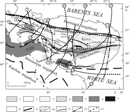
Figure 3 - Weak
zones in the Kola region basement formed in the Early Precambrian in the time
interval of 3.0–1.6 Ga.
(1) Archaean belts: Kolmozero-Voronje,
Tersky-Allarechka, and Yona;
(2) Keivy
structure; (3) Highly alumina
gneiss of the Keivy series (polar fox tundra column);
(4) Anorthosite
intrusions and gabbro–anorthosites (Archaean–Early Proterozoic); (5) Pechenga-Imandra-Varguza paleorift belt; (6)
Lapland granulate belt; (7)
Layered massifs of basic and ultrabasic rocks (Early Proterozoic); (8) Alkaline intrusions (Paleozoic); (9) Fractures (fracture zones) at the
contact between megablocks; (10) (a) State
border of Russia, (b) modern
coastline. Magma conducting (weak) zones distinguished on the basis of
anomalous values of simulated maximum shear stresses: (11) formed in the interval of 3.0–2.8 Ga;
(12) in the interval of 2.8–2.5
Ga; (13)
in the interval of 2.5–1.6 Ga. Numbers in circles indicate distinguished zones:
(1) Kolmozero–Voronja belt; (2) Terskii–Allarechka
belt; (3) Tsaga zone; (4) Shchuchieozero
zone; (5) Tuloma zone; (6) Kolvitsa
zone; (7) Liinakhamar zone; (8) Mt. Generalskaya; (9) Porjitash zone;
(10) Salny Tundra zone–1; (11) Salny
Tundra zone–2; (12) Moncha Tundra zone; (13) Khibiny zone; (14) East Kola zone; (15) North Kola zone (Kolmozero–Voronja); (16) Vaynospaa
zone; (17) Pechenga zone; (18) Litsa–Araguba
zone; (19) Kola–Imandra Lake zone; (20) Kontozero–Khibiny–Kovdor zone; (21) Continuation of the
western slope of the East Barents Sea rift system; (22) Continuation of the
eastern slope of the East Barents Sea rift system; (23) East Keivy–Panarechka zone; (24) Imandra–Varguza
zone; (25) Kandalaksha zone.
Results and discussions. Figure 3 presents the weak zones in the region distinguished from the
anomalous values of maximum shear stresses. They formed in the Late Archaean–Early Proterozoic. These regions have a shape of
belt structures and correlate with the regions of mafic-ultramafic intrusions distribution
and with zones of tectonic distortions in the Kola region. The simulations for
the first basic model (Fig. 2a) allowed us to distinguish weak zones 1–7, zones 8–14 in the second basic model (Fig.
2b), and zones 15–25 in the third basic model (Fig.
2c). The distinguished zones 1–4 (Kolmozeo–Voronja
(1), Terskii_Allarechka
belt (2), Tsaga
(3), and Shchuchieozero
(4)) are known from the
geological data as the Archaean magma conducting
regions. This was confirmed by the results of modeling. Zones 5–6 (Tuloma (5)
and Kolvitsa (6)) are known as Early Proterozoic ones.
Zone 7 (Liinakhamar) is traced along the fracture of
the northeastern direction that crosses the Murmansk and Kola megablocks. The regional
geologists consider that the fractures of the northeastern extension are Archaean. The distinguished zones 8–12 (Mt. Generalskaya (8), Porjitash
zone (9), Salny
Tundra zone 1 (10), Salny Tundra zone 2 (11),
Moncha Tundra zone (12)) are Early Proterozoic. Zone 13 (Khibiny) is known as Paleozoic.
Zone 14 (East Kola) spreading in the submeridional direction that crosses the eastern part of
the Kola Peninsula and the White Sea basin is not considered as a magma
conducting structure; its age and genesis are not known. It is worth noting that
zone 14 crosses the system of fractures shown in tectonic schemes [4,16,18] at
an angle of 10°. The admitted estimate of the origination time is Late Archaean. Zone 15 (North
Kola) is known as Archaean (Kolmozero–Voronja),
but magmatic activity was also later observed in this region. Zones 16–19 (Vaynospaa
(16), Pechenga
(17), Litsa–Araguba
(18), and Kola–Imandra Lake (19))
are Early Proterozoic. Zone 20 (Kontozero–Khibiny–Kovgor) is known as Paleozoic. Zones 21 and 22 are continuations of the slopes of the Eastern Barents Sea
rift system of Paleozoic age (continuation of the western slope (21), continuation of the eastern slope
(22)). Zones 23 and 24 (Eastern Keivy–Panarechka (23), Imandra–Varzuga
(24) are of Early Proterozoic
age, and zone 25 (Kandalaksha) is known as Riphean.
Any critical situations in the origination
of the ancient crust could have caused formation of deep fractures (activation
regions) precisely in the weak zones that control the location of ore belts of
sequential metallogenic epochs. Model simulations
provide evidence of this viewpoint. These demonstrate that the main magma - releasing
structures of the region are characterized by anomalous shear stresses. Identified weak zones
in the basement of the Kola region
are mostly superimposed and do not change the shape of enclosing megablocks and
together form a frame, which unites the main structural elements (Archean megablocks) of the region (Fig 4). Figure 4 shows that the reconstructed ancient mobile permeable structures
1-3 extend from northwest to southeast, structures 4-8 - from the southwest to
the northeast. Areas 1, 2, 3, and 5 formed in the Archean
as weakened zones, areas 4, 6, 7, and 8 - in the early Proterozoic. It should
be noted that the central part of structures 6, 7, and 8 (within the Kola megablock) began to form even in the Archean
time.
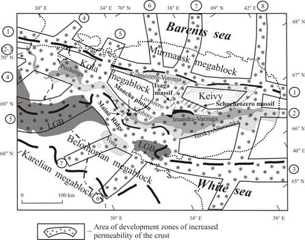
Figure 4 - Scheme of the location of the
ancient deformation magmatic structures (frame tectonogens)
in the northeastern part of the Baltic Shield. Numerals in circles indicate
reconstructed mobile permeable zones in the Archean basement of the region.
Symbols are shown in fig.
3.
Mobile permeable zones formed in the crust of the region may be considered
as frame tectonogens, which according to the
terminology suggested by Sheinmann, Yu.M. [17] represent linear deformation igneous structures.
These structures were the regions of stress relaxation in the crust, along
which the crust was reconstructing during each of the tectonic cycles so that the
crust qualitatively changed. At each stage of the Earth’s crust development,
the geotectonic contrasts were intensified and, correspondingly, the structure
of tectonogens became more complex. Eventually, the
ancient Archaean blocks of the region were crossed by
a system of frame tectonogens controlling the local
energy accumulation, which led to sharp activation of tectonic, thermal, and igneous
processes.
Conclusions. The results of our research demonstrate that development of tectonogens (mobile permeable zones) is caused not only by
the influence of the deep mobile zones whose roots penetrate into the mantle,
but also by the stressed deformed state of the Earth’s crust subjected to the
influence of external tectonic forces. The investigations revealed the heredity of magma feeding
channels in the region from
the Archaean to the Early Proterozoic, which is confirmed by geological data. The analysis shows that the
areas where tectonogens of different ages intersect
are characterized by a wider range of multiple manifestations of the mafic - ultramafic magmatism
within the Kola region. Thus, a lens-shaped belt structure of the crust
was already formed in the Archaean, which along with
the vertical layering acquires lateral mosaic inhomogeneity. Hence, the system
of permeable zones in the basement of the Kola region formed in the Early
Precambrian determined the course of development of geodynamic and mantle igneous
processes in later epochs.
Notably, the seismicity in the Murmansk region has doubled in the last 30
years and is assumed to be capable of reaching 6 points on the MSK-64 scale. In
addition, the powerful mining complex of the region has been generating a
significant number of technogenic seismic events. The
geological environment is a very mutable structure, and its detailed study
shall be much expensive. The performed studies using
numerical modeling and available data on geology and tectonic structure made it
possible to identify the weakened zones (areas of activation) in the geological
basement of the region. The
obtained results allow choosing the most favorable areas for
construction and conducting a special study within them. At the
same time, it saves time and money, and the
informative value of the results may be useful in solving a wide range of
construction tasks. The
methods that were developed in this research may be used as those of express
diagnosis that make it possible to identify weak zones in the basement and
estimate degree of their permeability with minimum time and cost.
References:
1.
Balagansky, V.V., 2002. Tectono-stratigraphic
terrain analysis as a basis for tectonic zoning. In F.P.Mitrofanov
(Ed.), Geology and mineral resources of the Kola Peninsula. Vol. 1. Geology,
geochronology and geodynamics. Publishing House of the Kola Science Center of
the Russian Academy of Sciences, Apatity, 44-56 (in
Russian).
2.
Barbey, P., Convert, J., Moreau, B., Capevila, R. and Hameurt, J.,
1984. Petrogenesis and evolution of an early
Proterozoic collision orogenic belts: the granulite belt of Lapland and Belomorides (Fennoscandia). Bulletin of the Geological Society of Finland,
56(1-2): 164- 188.
3.
Bayanova, T.B., Pozhilenko,
V.I., Smol’kin, V.F., Kudryashov,
N.M., Kaulina, T.V. and Vetrin,
V.R., 2002. Catalogue of geochronological data for
the northeastern part of the Baltic shield. Publishing House of the Kola
Science Center of the Russian Academy of Sciences, Apatity,
53 pp (in Russian).
4. Bel’kov,
I.V. (ed.), 1987. Evolution of the
Earth’s Crust and Endogenous Metallogenic Zonality in the
Northeastern Part of the Baltic Shield. Nauka,
Leningrad, 112 pp (in Russian).
5. Berthelsen,
A. and Marker, M., 1986. Tectonics of Kola collision suture and
adjacent Archean
and Early Proterozoic terrains in the north-eastern region of the
Baltic Shield. Tectonophysics, 126(1): 31-55.
6. Crouch, S.L and Starfield, A.M., 1983. Boundary Element Methods in Solid Mechanics. George Allen & Unwin, London (UK),
322 pp.
7.
Filatova, V.T., 2009. Evaluation of the strassed deformed State of the Earth's crust in the northeastern part of the Baltic Shield
in the Late Archaean. Doklady
Earth Sciences, 424(1): 118-122.
8. Kroner, A.
and Compston, W., 1990. Archean
tonalitic gneiss of Finish Lapland
revisited: zircon ion-microprobe ages. Сontributions to
Mineralogy and Petrology,
104(3):
348-352.
9. Melezhik, V.A. and Sturt, B.F., 1994. General
geology and evolutionary history of
the Early Proterozoic Polmak - Pasvik - Pechenga - Imandra - Varzuga - Ust’Ponoy
Greenstone Belt in the Northeastern Baltic Shield.
Earth-Science Reviews, 36(3-4):
205-241.
10.
Mints, M.V., Glaznev, V.N., Konilov,
A.N., Kunina, N.M., Nikitichev,
A.P., Raevsky, A.B., Sedikh,
Yu.N., Stupak, V.M. and Fonarev,
V.I., 1996. The Early Precambrian of the Northeastern Baltic Shield: Paleogeodynamics, Crustal Structure and Evolution. Transactions
of GIN RAS, vol. 503. Scientific World, Moscow, 277 pp (in Russian with English
Abstract).
11. Mitrofanov,
F.P. (ed.), 1996. Geological Chart of the Kola Region
(Northeastern Part of the Baltic Shield) (Scale 1: 500 000). Publishing
House of the Kola Science Center of the Russian Academy of Sciences, Apatity (in Russian).
12.
Mitrofanov, F.P., Pozhilenko, V.I., Smolkin, V.F., Arzamastsev, A.A., Yevzerov, V.Ya., Lyubtsov, V.V., Shipilov, E.V.,
Nikolaeva, S.B., Fedotov, Zh.A., 1995. Geology of the Kola Peninsula (Baltic Shield). Publishing
House of the Kola Science Center of the Russian Academy of Sciences, Apatity, 144 pp.
13. Muskhelishvili,
N.I., 1966. Some of the Main Problems
of the Mathematical Theory of Elasticity. Nauka, Moscow, 707 pp
(in Russian).
14.
Petrov, V.P., 1999. Early Proterozoic Metamorphism in
the Baltic Shield. Publishing House of the Kola Science Center of the Russian
Academy of Sciences, Apatity, 325 pp (in Russian with
English Abstract).
15.
Petrov, V.P., Belyaev,
O.A., Voloshina, Z.M., Bogdanova,
M.N. and Ivliev, A.I., 1986. Metamorphism of supracrustal
complexes of the Early Precambrian age (northeastern part of the Baltic shield).
Nauka, Leningrad, 272 pp (in Russian).
16. Radchenko,
A.T., Balaganskii,
V.V., Vinogradov, A.N., Golionko,
G.B., Petrov, V.P., Pozhilenko,
V.I. and Radchenko, M.K., 1992. Precambrian Tectonics of the Northeastern
Part of the Baltic Shield (explanatory note to the tectonic chart 1: 500 000). Nauka, St.
Petersburg, 111 pp (in Russian).
17. Sheinmann,
Yu.M., 1968. Notes
on the Deep Geology. Nedra, Moscow, 231 pp (in Russian).
18. Zagorodnyi,
V. G. and Radchenko, A.T., 1983. Tectonics of the Early Precambrian in the
Kola Peninsula (State of the Investigation and Problems). Nauka, Leningrad, 96 pp (in Russian).
About the author:
Filatova V.T., Dr. Sc.(Phys. & Math.), Lead
Researcher,
Geological
Institute of the Kola Science Centre of the Russian
Academy of Sciences, 14, Fersman street, Apatity, 184209, Russia